Russian LNG Carrier Goes Dark in Norway’s Arctic Waters to Circumvent Sanctions
LNG carrier unloading liquefied natural gas in port. (Source: Jens Schott Knudsen under CC BY-NC 2.0)
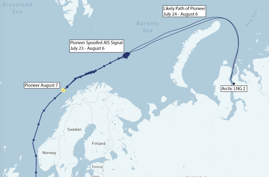
A Russia-affiliated LNG carrier circled for two weeks to the North of Norway. It disappeared sending out false vessel tracking signals, traveled to sanctioned Arctic LNG 2 and reappeared this week off Norway’s coast.

A game of maritime cat and mouse has been unfolding in Norway’s Arctic waters of the Barents Sea for the last two weeks. A liquefied natural gas (LNG) carrier effectively went into hiding on July 23 sending out a false transponder signal and reappeared off Norway’s coast 14 days later on August 7.
For months shipping and energy experts cautioned that Russia may resort to using a “dark fleet,” where vessels turn off their automatic identification system (AIS) transponders, to begin carrying LNG from the sanctioned Arctic LNG 2 project.
Exactly that scenario transpired around 250 nautical miles from the Nordkapp half way between continental Norway and the archipelago of Svalbard.
A suspect vessel from the start
The LNG carrier Pioneer had already been on the radar of industry insiders as a potential candidate for a dark vessel operation following recent ownership changes. The aging vessel, built in 2005, entered into an elliptical holding pattern toward the end of July after slowing traveling up Norway’s coastline.
AIS track showing Pioneer traveling up Norway’s coast in July before going dark and reemerging on August 7. (Source: Shipatlas with HNN annotations)
The AIS signal originating from the automated transponder soon became perfectly symmetrical; an impossibility for a vessel navigating in open waters and a clear sign that Pioneer had begun sending out a fake signal. The so-called spoofing allowed the vessel to navigate away from its recorded position undetected. Anyone looking at vessel tracking sites would have continued to see Pioneer doing loops in the Barents Sea.
Pioneer appears at Artic LNG 2
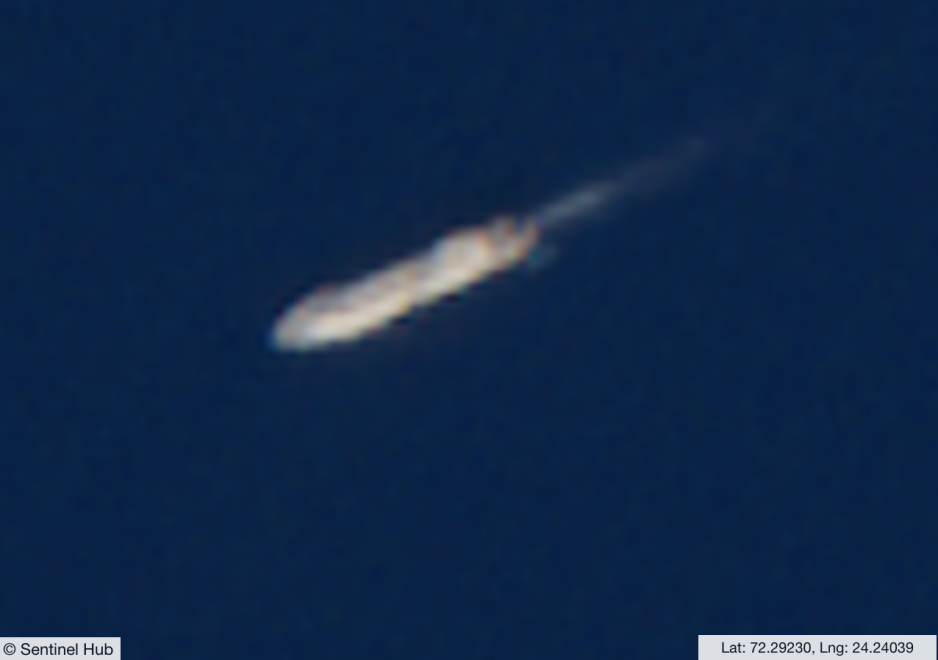
Around a week later, on August 2, the vessel was detected at the Arctic LNG 2 project around 1000 nautical miles away using satellite images. Its AIS signature meanwhile remained north of Norway. Further investigations showed the vessel traveling around the northern tip of Novaya Zemlya the previous day and then receiving an icebreaker escort as it headed toward Ob Bay and the gas project.
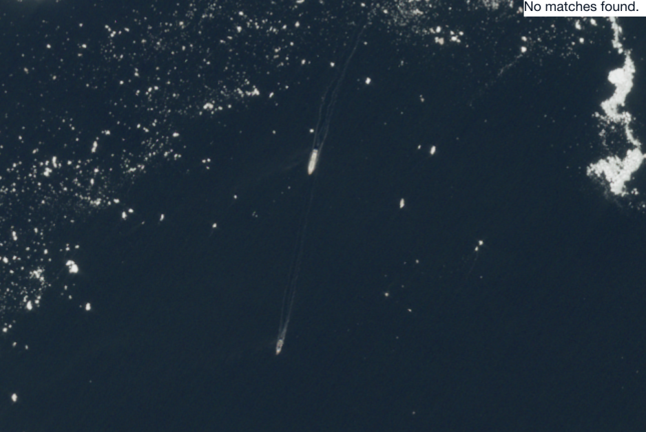
Pioneer traveling behind an icebreaker en route to the Arctic LNG 2 project. (Source: Sentinel Hub)
Adverse weather prevented satellite detection of Pioneer’s departure from Arctic LNG 2 but Synthetic Aperture Radar (SAR) aboard the European Space Agency's Sentinel-1A/B satellites provided continuous all-weather, day-and-night observation. These grainy images suggested that around August 6 the vessel was returning to its spoofed location in order to effectively re-integrate with its transponder signal as if nothing had happened.
Vessel tracking sites show this exact scenario occurring the evening of August 6 when the perfect elliptical pattern ended and the vessel reemerged traveling southwest toward the Norwegian coastline.
Pioneer emerging from its spoofed pattern on August 6. (Source: Vesselfinder)
Pioneer reemerges near Norway's coast
Less than 24 hours later, as it reached an area without clouds obscuring its scheme, visual satellite images were able to pick up its path once again. Its destination currently remains unknown and though there is no official confirmation that it loaded cargo at the LNG project, industry experts concur that its trip to Arctic LNG 2 and the timeline confirm exactly that scenario.
Pioneer reemerges around 100 nautical miles northwest of Norway on August 7. (Source: Sentinel Hub)
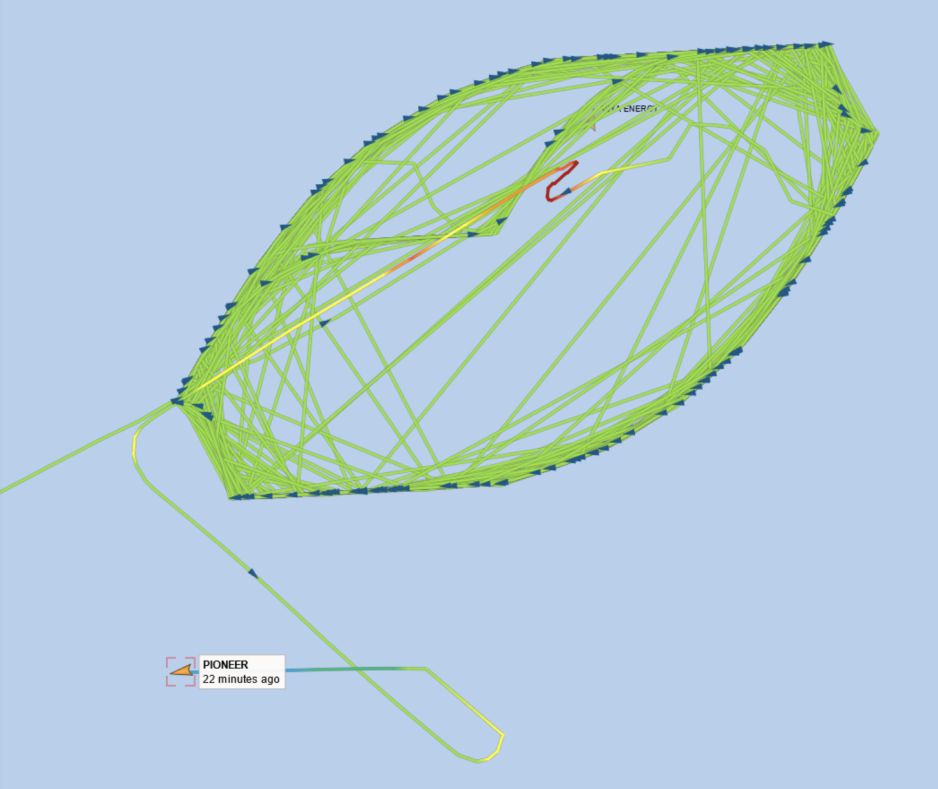
Game of cat and mouse in Norwegian waters
The events largely transpired in the traffic control area of the Norwegian Coastal Administration (Kystverket) Vardø VTS center. At least part of the spoofing activity may also have been located within Norway’s exclusive economic zone. The Vardø center did not respond to requests for comment in time for publication. It is also not clear what actual jurisdiction the Kystverket or Norway generally may have apart from monitoring the situation.

Vessel tracking map by Norway’s Kystverket showing location of Pioneer on August 7. (Source: Kystverket)
“Carrying and transmitting an AIS device is compulsory for all vessels over 300 UMS [register tons], as required by the IMO Solas Convention,” explains Hervé Baudu, Arctic shipping expert and Chief Professor of Maritime Education at the French Maritime Academy (ENSM).
Turning off a vessel’s AIS transponder or sending out a false signal does violate international maritime law, but it would be up to the flag state – in the case of Pioneer it would be the state of Palau – to issue any penalties, maritime experts explain.
“It is forbidden to scramble or usurp the identity of an AIS transmission. While voyage information can be modified by the crew, information about the ship and its identity (IMO registration number, MMSI emission, etc.) is the responsibility of the flag State.”
“In practical terms, only the flag state can penalize a ship registered in that state if it fails to comply with best practice,” concludes Baudu.
")
")