New Microsatellite Launched to Strengthen Norwegian Ocean Surveillance

NorSat-4 is the fifth in line of Norwegian satellites for maritime surveillance and will now also contribute to demonstrating new technology in space. (Illustration: FFI)
The microsatellite NorSat-4 is now orbiting the Earth to enhance Norway’s maritime situational awareness. “It is of extra significance in today's geopolitical climate," says the Norwegian Coastal Administration's Director General.
The Norwegian microsatellite NorSat-4 began its voyage in space on Tuesday night, Norwegian time.
It hitchhiked with SpaceX's Falcon rocket from Vandenberg Space Force Base in California, USA, as Norway's Arctic broadband satellites did in August.
This satellite is part of the Norwegian Coastal Administration's space program for ocean surveillance and will draw AIS signals from ships sailing in Norwegian waters.
AIS (Automatic Identification System) provides information on vessels' identity, position, speed, and course, which, in turn, contributes to ensuring safe sea traffic, detecting illegal fishing and other crimes, and surveilling maritime borders, among other things.
NorSat-4 also carries two payloads for the Norwegian Armed Forces: a newly developed low-light camera to photograph ships that have turned off their AIS sender in an attempt to be invisible, as well as a prototype for encrypted data transfer between satellite and ground station.
"This satellite strengthens Norway's ability to track what goes on in our ocean areas. This is of extra significance in today's geopolitical climate," says Einar Vik Arset, Director General of the Norwegian Coastal Administration.
Paves the way for more robust infrastructure
NorSat-4 was developed in a cooperative between the Norwegian Space Agency, the Norwegian Coastal Administration, and the Norwegian Defence Research Establishment (FFI). It is funded by the Coastal Administration and the Norway's Ministry of Defense.
Both the Norwegian and foreign space industry are on the supplier side. The satellite was completed by UTIAS Space Flight Laboratory in Canada, using equipment from Kongsberg Discovery, Eidsvoll Electronics (Eidel), and French Safran Reosc.
The microsatellite will provide an overview of ship traffic to ground stations in Vardø and Tromsø.
"Both the low light camera and the payload for encryption will pave the way for new services and more robust space infrastructure. This is very important for further developing our national capabilities in space," said Christian Hauglie-Hanssen, the CEO of the Norwegian Space Agency.
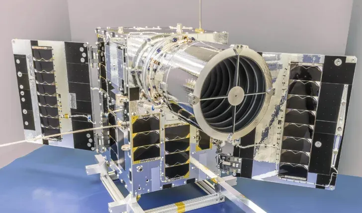
NorSat-4 weighs approximately 35 kilograms and measures 76 x 83 x 43 centimeters when the antennas and solar panels are unfolded. (Photo: SFL)
Enhanced camera capabilities
The low-light camera is designed by FFI, which will be primarily responsible for testing and evaluating it together with the Norwegian Armed Forces and the Coastal Administration.
"AIS recordings from satellites entailed significant progress when we demonstrated it in 2010. We have seen a need for other sensor technologies to verify the AIS messages and complete the surveillance picture. The navigation radar detector on NorSat-3 and this new camera are FFI's latest contribution to national maritime surveillance via satellites," says Trygve Sparr, Director of Research at FFI.
The camera is designed with a large aperture angle. It should be able to detect ships more than 30 meters long, also in darkness and other challenging lighting conditions.
"From FFI's control center, we can point the camera towards cloud-free areas based on meteorological predictions. This increases the detection possibilities significantly," FFI researcher Knut Svenes explains.
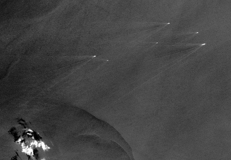
The low-light camera will be able to roughly make these types of ship observations. This illustration was developed using data from NASA's Earth observation satellite Ladsat-8. (Image: US Geological Survey)
Encryption solution
Satellites also need data and communication security, and NorSat-4 offers a first opportunity to test Norwegian-developed encryption equipment.
Eidsvoll Electronics developed the payload Nanosat crypto unit with funds from the Ministry of Defense. It will protect the transmission of data transfer and the satellite itself from hacking.
According to FFI, the aim is for future satellites used by the defense sector and government agencies to have encrypted communications that satisfy national security needs.
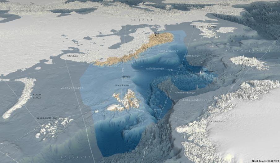
NorSat-4 will soon be in action as a guardian of Norway's vast ocean areas, here seen from the north. (Map: the Norwegian Polar Institute 2023)
Next phase
Over the course of the following weeks, the microsatellite and its payloads will be tested and verified.
"We will turn on the systems aboard individually and gather telemetry to ensure all values are normal. We control that the satellite is pointing in the right direction and turn on the payloads one by one to test them," explains Eirik Voje Blindheim, Project Manager for NorSat-4 at the Norwegian Space Agency.
"The ship surveillance will be prioritized, so the first AIS data from NorSat-4 will likely arrive after just a few days," he says.
More specifically, NorSat-4 and the AIS receiver are owned by the Coastal Administration, while the two other payloads are owned and controlled by FFI.
The satellite will be operated by Statsat, a Norwegian state-owned company, from its control room in Oslo. FFI will control the camera and analyze its photos.
Part of portfolio
The work on NorSat-4 started in 2019 and has been led by the Norwegian Space Agency.
It will be the fifth in line of Norwegian satellites in operation for the Coastal Administration, in which the first (AISSat-1) orbited the earth in 2010. The oldest two will likely be retired this year.
"NorSat-4 is part of the portfolio of national microsatellites for maritime surveillance, and the Norwegian Space Agency is responsible for maintaining this capability. Older satellites are gradually phased out, and NorSat-4 is a very important addition to maintain both access to AIS data and test new technology," states CEO Hauglie-Hanssen.
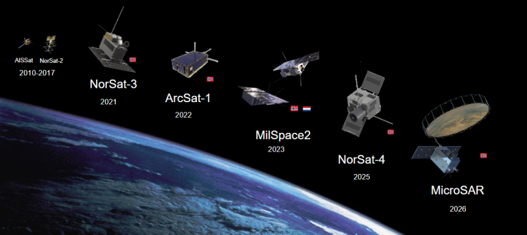
Overview of past, current, and upcoming Norwegian microsatellites that FFI has been or is involved in developing. ArcSat-1, launched in 2019, was Norway's first communications satellite for military operations in the High North. The MilSpace satellites, launched into polar orbit in 2023, were developed in collaboration with the Netherlands to test the geolocalization of radar transmitters. Space Norway's radar satellite MicroSAR will provide real-time monitoring of Norwegian ocean areas with advanced capabilities. (Illustration: FFI)


